Hello!
Welcome to the CWU Center for Spatial Information Kittitas Water Rights Mapping Project. Turn on and off layers in the left hand layer panel to view different layers. Or search for locations or features in the right hand panel.
Click on a feature in the map to get information about that feature. Feel free to expand/collapse the popups or move them around by clicking on the the pin icon.
Have fun and play around.
Happy Mapping!
Be sure to click on the links below for further information about resources.
This website does not cover
ALL water rights for the state of Washington. This is just a user interface to help with decision support for the Kittitas County area.
Links
Washington State Department of Ecology
Central Washington University
Central Washington University Center for Spatial Information
RGIS
DisclaimerThe data contained in this geo-spatial database has been compiled from a broad array of sources. It is provided without warranty of any kind. The Center for Spatial Information does not warrant, guarantee, or make any representations regarding the use of, or results from the use of the Data in terms of correctness, accuracy, reliability, currentness, or otherwise. Use these data solely at your own risk.
About Metadata
Water Resource data in the Yakima Basin is continually collected and refined. Every attempt has been made to collect the most recent data available. Users are strongly encouraged to contact the agencies responsible for these data to obtain the most recent data available.
Bureau of Reclamation Reservoir Levels
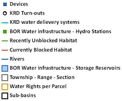
Layers: BOR Water infrastructure - Hydro Stations, BOR Water infrastructure - Storage Reservoirs.
Description: This is a series of shapefiles including the outline of Bureau of Reclamation maintained reservoirs in the Upper Yakima Basin and stream gages. The Bureau of Reclamation is currently updating these data with more precise GPS units in an effort to increase the precision of these data. The hyperlinks lead to Bureau of Reclamation-run websites containing reservoir and stream gage data.
Source: U.S. Bureau of Reclamation--Yakima Field Office
Date Obtained: August, 2010
Format of Data Obtained: Geographic Information Systems Shapefiles
Contact Information: U.S. Bureau of Reclamation--Yakima Field Office
Physical Address: 1910 Marsh Road Yakima, WA 98901-2058
Phone: (509) 575-5848
Website:
http://www.usbr.gov/pn/about/contact.html
Kittitas Reclamation District Canal Data
Layers: KRD water delivery systems.
Description: This is a Geographic Information System shapefile of the canals operated by the Kittitas Reclamation District (KRD). The ID numbers are those assigned by the KRD.
Source: Kittitas Reclamation District
Date Obtained: August, 2010
Format of Data Obtained: Geographic Information Systems Shapefiles
Contact Information: Kittitas Reclamation Districte
Physical Address: 315 North Water St. Ellensburg, WA 98926
Phone: (509) 925-6158
Website:
http://krdistrict.org
Kittitas Reclamation District Turnouts Data
Layer KRD Turn-outs.
Description: This is a Geographic Information System shapefile of the turnout (points where water is extracted from a watercourse) for the Kittitas Reclamation District (KRD). The ID numbers are those assigned by the KRD.
Source: Kittitas Reclamation District
Date Obtained: August, 2010
Format of Data Obtained: Geographic Information Systems Shapefiles
Contact Information: Kittitas Reclamation Districte
Physical Address: 315 North Water St. Ellensburg, WA 98926
Phone: (509) 925-6158
Website:
http://krdistrict.org
Washington Department of Ecology Water Rights Data
Layers: Water Rights, Devices.
Description: Dataset contains two categories of water rights data, devices and Place of Use. Both databases are updated frequently, so check with the Department of Ecology for the most up-to-data data. Online data dictionaries exist for both data sets on the Department of Ecologys website.
Source: State of Washington Department of EcologyYakima Field Office
Date Obtained: August, 2010
Format of Data Obtained: Geographic Information Systems Shapefiles and html
Contact Information: Washington State Department of Ecology-Yakima Field Office
Physical Address: 15 W. Yakima Ave #200 Yakima, WA 98902
Phone: (509) 575-2490
Website:
http://www.ecy.wa.gov/directory_cro.html
Salmon Habitat Availability
Layers: Recently Unblocked Habitat, Currently Blocked Habitat.
Description: These data, from the Yakima Basin Steelhead Recovery Plan (extracted from the 2005 Yakima Subbasin Salmon Recovery Plan), show areas accessible to steelhead and coho salmon, as well as areas currently blocked to upstream migration.
Source: Yakima Basin Fish and Wildlife Recovery Board
Date Obtained: August, 2010
Format of Data Obtained: Geographic Information Systems Shapefiles
Contact Information: Yakima Basin Fish and Wildlife Recovery Board
Physical Address: 1110 West Lincoln Ave Yakima, WA 98902
Phone: (509) 453-4104
Website:
www.ybfwrb.org